Electronic Atlas
Glaciers of Georgia
Pirikiti Alazani River Basin
a
b
c
d
Fig. 1. Contours of glaciers No. 6 – 8 (Chero), No. 9 – 11 (Diklo), No. 12 (Diklo): a – according to the topographic map, b – according to the Landsat 5 TM sensor image of September 21, 2011, c – according to the Landsat 8 OLI TIRS sensor image of August 28, 2014, d – according to the Landsat 8 OLI TIRS sensor image of September 13, 2020.
a
b
c
d
Fig. 2. Contours of glaciers No. 13 − 19: a – according to the topographic map, b – according to the Landsat 5 TM sensor image of September 21, 2011, c – according to the Landsat 8 OLI TIRS sensor image of August 28, 2014, d – according to the Landsat 8 OLI TIRS sensor image of September 13, 2020.

Note:
13 − 19 Glacier names: 13 − Chigo Glacier; 96; 14 − Chigo Glacier, 97; 15 − Chigo Glacier, 100; 16 − South-West Didikhevi Glacier; 17 − North-West Didikhevi Glacier; 18 − Central Didikhevi Glacier; 19 − West Didikhevi Glacier.
a
b
c
d
Fig. 3. Contours of glaciers No. 20 (Western Komi): a – according to the topographic map, b – according to the Landsat 5 TM sensor image of September 21, 2011, c – according to the Landsat 8 OLI TIRS sensor image of August 28, 2014, d – according to the Landsat 8 OLI TIRS sensor image of September 13, 2020.
a
b
c
d
Fig. 4. Contours of glaciers No. 21 – 23 and No. 15 of the Arghun basin (No. 6-10,): a – according to the topographic map, b – according to the Landsat 5 TM sensor image of September 21, 2011, c – according to the Landsat 8 OLI TIRS sensor image of August 28, 2014, d – according to the Landsat 8 OLI TIRS sensor image of September 13, 2020.

Note 1:
Fig. 3 of the Arghuni basin and Fig. 4 of the Pirikiti Alazani are identical.
Note 2: Names of glaciers No. 21 – 23: 21 – Dakvekhi Glacier; 22 – Western Tebulo; 23 – Atsunta.
a
b
c
d
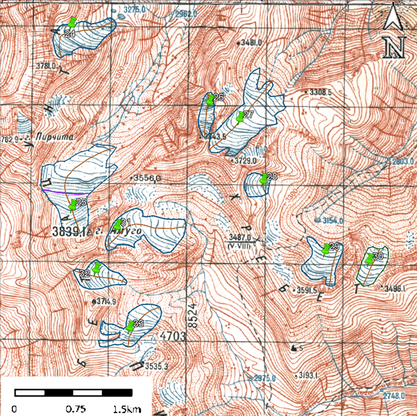
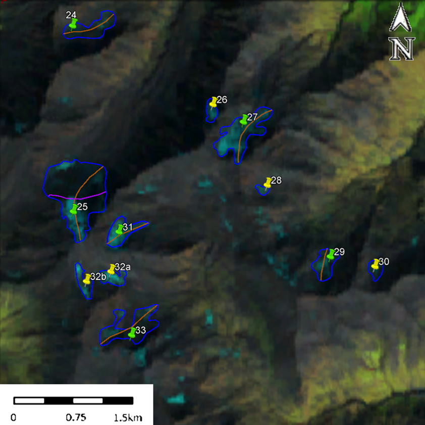
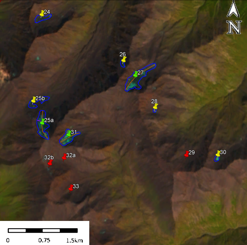
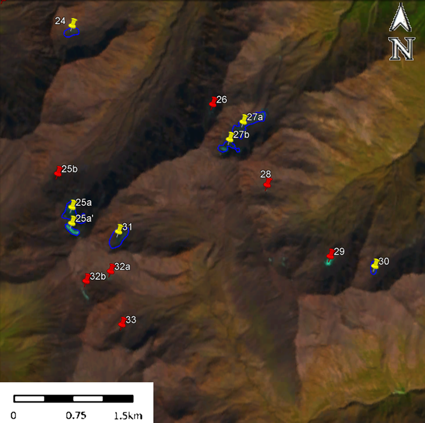
Fig. 5. Contours of glaciers No. 24 – 33: a – according to the topographic map, b – according to the Landsat 5 TM sensor image of September 21, 2011, c – according to the Landsat 8 OLI TIRS sensor image of August 28, 2014, d – according to the Landsat 8 OLI TIRS sensor image of September 13, 2020.

Note:
Names of glaciers Nos. 24 – 25 and 27 – 33: 24–Pirchita Glacier; 25–Northern Amugo; 27–Kvakhidi Glacier, 110a; 28–Kvakhidi Glacier, 110b; 29–Kvakhidi Glacier, 110c; 31–Eastern Amugo; 32–Larovani Glacier, 112; 33–Larovani Glacier, 112b.
USEFUL LINKS
Institute of Hydrometeorology of GTU © 2025. All rights reserved.